


WalkMe | Walking in Madeira
4.612.00 Reviews
App Specs
- Version
- 8.4.1
- Updated On
- License
- Free
- Downloads
- 100,000+
- Developer
- WalkMe Mobile Solutions
- Categories
- Travel & Local
- Platform
- Android
Screenshots
 Analysis by AppCompare
I’d treat WalkMe | Walking in Madeira as a trail companion to prepare with before leaving, rather than something to install at the trailhead and figure out while walking. Its focus is Madeira’s walking routes, so the first useful step is to browse for a walk that suits your time, confidence and plans for the day. That simple bit of preparation can make a first outing feel much less daunting, especially if you’re unfamiliar with the island.
This is a free travel and local app from WalkMe Mobile Solutions, with optional in-app purchases ranging from $7.99 to $49.99 per item. It has a 4.6 average from around 1.8 thousand ratings and more than 100 thousand installs, which suggests that many walkers have found it worth trying. It is rated for Everyone, and the current version is 8.4.1. Those details make it easy to decide whether it is suitable for your device and budget, but the real question is whether its route-focused approach matches the way you like to explore.
What to expect from a Madeira trail guide
WalkMe is most useful when you want your walk to be the main event, not just a line between sightseeing stops. Madeira’s trails can take you away from familiar streets and into landscapes where a little context helps. A dedicated walking guide can keep route information and trail notes together, while a general map app is usually better for finding a restaurant, a bus stop or a quick way across town.
I would not assume that a phone guide replaces ordinary hiking judgement. A route description can help you plan, but conditions, daylight, fitness and footwear still matter. If your idea of a holiday walk is a short, casual stroll with no interest in trail details, a standard map may be enough. If you want to choose a proper walk and understand what you are setting out to do, a specialist app has a clearer purpose.
Getting ready before your first walk
When you first open the app, take a little time to look through the available trail information instead of choosing solely by an appealing photo. Compare the descriptions with how much time and energy you have, and think about who is coming with you. A route that sounds exciting on screen may be a poor choice for a tired group or for someone who is not used to walking on uneven ground.
Before setting out, make the map preparation part of your routine. If the route can be saved for offline use, download what you need while you have a reliable connection, then check that the relevant material is available on your phone. This is a practical habit rather than a guarantee that every situation will be covered: keep your phone charged, and do not rely on mobile reception as your only safety measure.
A useful first outing is one where the goal is simply to follow a route at a comfortable pace and learn how the app fits into your day. You do not need to turn the walk into a personal challenge or cover as much ground as possible. Notice whether the route notes answer the questions you have, whether the map is easy to read outdoors, and whether you prefer checking it at planned stops instead of constantly looking at your screen.
Worth Reading Before You Choose

Flipboard Shows What News Apps Must Do Beyond the Feed

Switching to Android Auto Means Rethinking Your Driving Routine

Google Calendar Makes a Crowded Week Easier to Manage

Ludo King Makes the Most of the Minutes Between Plans

Baby Panda World Brings Quick Play to Modern Phones, but Its Game Library Feels Busy

ESPN’s Live Game View Makes Following Close Games Easier
Making the guide work for you
It helps to think of a hiking app as one part of a small planning system. I would use WalkMe to choose and follow a Madeira walk, keep a separate note of the meeting point or transport plan, and tell someone where I intend to go if I’m walking alone. That division keeps the app useful without asking it to handle every detail of the day.
There is also a trade-off in taking a phone onto a long walk: the screen is convenient, but checking it repeatedly can use battery and pull your attention away from the path. I’d look at the route at a safe stopping point, then put the phone away while walking. Carrying water and wearing shoes suited to the terrain are still more important than any app feature.
Discovering Madeira, One Step at a Time
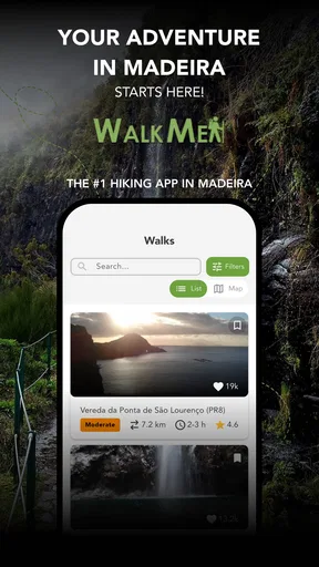
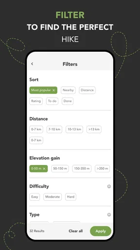
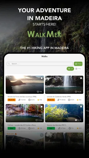
Madeira is known for its stunning landscapes, and WalkMe | Walking in Madeira truly captures this essence. As soon as I opened the app, I was greeted with an intuitive interface that made it easy to navigate. The app categorizes trails based on difficulty, making it perfect for both beginners and seasoned hikers. Whether you’re looking for a leisurely stroll or a challenging hike, there’s something for everyone.
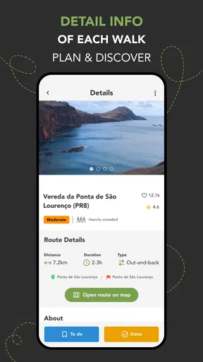
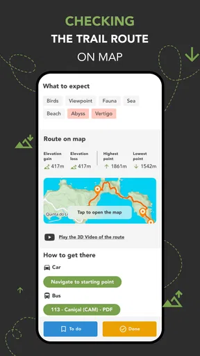
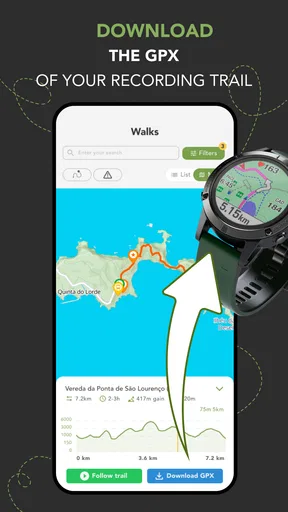
The app offers detailed maps, which I found incredibly helpful. Each trail comes with a description, photos, and user reviews, so you know exactly what to expect. The real-time GPS tracking is a lifesaver, especially if you’re like me and have a knack for getting lost. It ensures you stay on the right path while enjoying the stunning views.
Features That Elevate Your Adventure
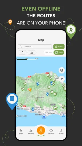
One of the standout features of WalkMe is the offline map access. Before heading out, you can download the trails, which is perfect for areas with spotty cell reception. Trust me, it’s a game-changer when you’re deep in nature.
Another cool feature is the community aspect. The app has a vibrant community of walkers who share tips, photos, and experiences. I found it incredibly motivating to see other users’ adventures and get inspired by their journeys. Plus, the app allows you to log your hikes, track your progress, and even set personal goals. It’s like having a fitness buddy cheering you on every step of the way.
Enhancing the Walking Experience
The app’s attention to detail is impressive. With WalkMe, you get more than just directions; you get insights into Madeira’s rich history and culture. The app provides fascinating tidbits about local flora, fauna, and landmarks, turning a simple walk into an educational experience. I loved learning about the history behind the trails and the unique ecosystem of Madeira.
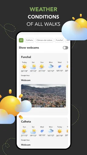
Safety is a top priority with WalkMe. The app provides weather updates and safety warnings for the trails, ensuring you’re prepared for any situation. It also has an emergency feature that allows you to quickly share your location with friends or family. It’s reassuring to know that help is just a tap away if needed.
A Few Tips for Your Journey
Before you set off on your Madeira adventure, here are a few tips. Make sure to wear comfortable shoes, bring plenty of water, and don’t forget your camera! The landscapes are Instagram-worthy, and you’ll want to capture those memories. Also, take some time to explore the local towns and enjoy the delicious cuisine—after all, you’ve earned it after a day of hiking.
One thing to keep in mind is that while the app is incredibly user-friendly, it’s always good to have a backup plan. Having a physical map or guidebook can be handy, especially if your phone battery decides to die in the middle of a trail. But thanks to WalkMe’s offline maps, you’re more likely to avoid these hiccups.
Overall, WalkMe | Walking in Madeira is a fantastic companion for anyone looking to explore this beautiful island. It combines practicality with a rich user experience, making your walking adventures unforgettable. Whether you’re a local or visiting for the first time, this app brings Madeira’s trails to life in a way that’s both engaging and informative.
So, lace up your hiking boots, download the app, and get ready to discover Madeira like never before. Happy walking!
Choosing a route that fits an ordinary day
For a first-time visitor, the strongest use case is a day when you have a few hours free and want a walk to shape the outing. I’d browse before breakfast, shortlist a route that looks manageable, then check the practical details again before leaving. That avoids a common holiday trap: choosing a trail because it looks dramatic, only to realize that the group wanted an easy afternoon and a relaxed meal afterward.
It can also help when different people in your group have different expectations. Ask everyone what “a good walk” means to them—steady scenery, a challenge, or a gentle outing—and use the route descriptions and difficulty categories to make the choice together. The app can support that conversation, but no difficulty label can account for every person’s pace or comfort, so I’d leave room to turn back or adjust plans if the day feels harder than expected.
Another practical habit is to decide in advance when you’ll consult the phone. For example, check the map before starting, again at a natural pause, and whenever the route itself makes you uncertain. This reduces screen distraction and gives you a chance to notice the landscape rather than treating the walk like a navigation test. A GPS display is useful guidance, not a substitute for looking at signs, terrain and your surroundings.
Where it differs from ordinary map apps
A general-purpose map is convenient for getting around Madeira as a whole: finding a starting point, checking nearby services or planning a drive. WalkMe has a narrower job. Its trail descriptions, photos, reviews and walking-focused material are more relevant when the question is “Which route should I take?” rather than “How do I get to this address?” I’d happily use both, because they solve different problems instead of competing for the same role.
Compared with a printed guidebook, a phone app is easier to consult while planning and can bring route information and GPS use into one place. A book, however, does not depend on battery life and can be easier to scan without handling a phone outdoors. My preference would be to use the app for preparation and route support, while keeping a basic backup plan for a long or unfamiliar outing. That is not distrust of the app; it is sensible planning for any walk where losing access to a screen would be inconvenient.
The community material is another useful difference from a bare map, but I’d read user contributions as personal context rather than a promise about current trail conditions. A photo or review can help you picture an outing, yet the person who posted it may have walked at a different time or with different expectations. Use those details to shape questions and expectations, not to skip your own preparation.
Small habits that prevent first-day frustration
If you’re new to the app, give yourself a calm first session before you need it. Open a route, read its description, look at the photos and reviews, and find out how the map behaves on your device. Then download the relevant offline material if available. Doing this at your accommodation or another comfortable place is less stressful than trying to learn the controls in wind, rain or while other people are waiting.
For a realistic example, imagine you have a free morning, a companion who walks less often than you do, and plans to meet friends later. I’d choose a route that leaves a generous time margin, check the walk’s information together, prepare the offline map, and agree on a turnaround point if anyone is tired. During the walk, I’d use the route guidance at stops rather than keep the display open. That approach makes the app part of a flexible plan instead of the reason to push on.
Battery management deserves attention because GPS use and screen time can add up on a long day. Start with a charged phone, keep unnecessary screen checks to a minimum, and carry a physical fallback if the route matters enough that a dead device would leave you uncomfortable. Offline access helps with connectivity; it does not solve a depleted battery, and that distinction is easy to overlook when preparing.
It is also worth being realistic about who should skip a specialist hiking guide. If you only want directions through town, rarely walk trails, or prefer a human guide to explain local context and adapt plans in person, this may not be the right main tool. Likewise, anyone expecting an app to make an unsuitable route safe should rethink the plan. WalkMe is best treated as support for a walk you have already judged appropriate, not as a replacement for experience, preparation or local advice when needed.
Turning the first walk into a useful test
After your first outing, take a minute to note what actually helped: whether route descriptions made the choice easier, whether offline preparation worked as you expected, and whether you liked checking the map on the move. If you logged the walk or set a personal goal, use that as a private way to reflect on your routine rather than feeling obliged to chase a target. The most useful setup is the one that makes you more comfortable exploring, not the one that keeps you staring at progress screens.
Because the app is free to start and offers in-app purchases, I’d explore the basic experience before deciding whether any paid item is worthwhile. The listed purchase range is $7.99 to $49.99 per item, so it makes sense to understand what you personally need before spending. You can still enjoy the idea of a guided Madeira walk without assuming that every optional purchase is essential; let your first route reveal whether extra content would solve a real problem for you.
WalkMe has been available since July 30, 2012, and its current version is 8.4.1. It requires Android 7.0 or later, a useful compatibility check before you plan around it. I’d install it ahead of travel, confirm it opens properly on my phone, and prepare a route while connected. Those small checks turn the first meaningful success into something simple: choosing a suitable Madeira walk, having its information ready, and setting off with a plan that still leaves room for common sense.
Pros
- Intuitive interface
- easy to navigate.
- Accurate GPS tracking for hikers.
- Comprehensive trail information provided.
- Offline maps available for remote areas.
- Regular updates with new trails.
Cons
- Limited language options available.
- Requires significant storage space.
- Battery consumption is quite high.
- No real-time weather updates.
- Premium features locked behind paywall.
FAQs for WalkMe | Walking in Madeira
What is WalkMe | Walking in Madeira and what does it offer?
WalkMe | Walking in Madeira is a mobile app designed to enhance your hiking experience in Madeira, Portugal. It offers detailed maps, trail descriptions, elevation profiles, and offline access. The app provides curated hiking routes, complete with points of interest, difficulty ratings, and estimated durations, ensuring a comprehensive guide for both novice and experienced hikers.
Is an internet connection required to use the app?
While an internet connection is necessary to initially download the app and any updates, WalkMe | Walking in Madeira offers offline capabilities. You can download maps and trail information beforehand, allowing you to access them without an internet connection during your hike, which is essential in remote or mountainous areas with limited connectivity.
Does the app provide real-time navigation and tracking?
Yes, WalkMe | Walking in Madeira includes real-time GPS navigation and tracking features. This allows you to track your progress on a trail, view your current location, and follow the recommended path. The app helps ensure you stay on course and provides peace of mind when navigating unfamiliar trails.
Are there any costs associated with using WalkMe | Walking in Madeira?
WalkMe | Walking in Madeira is free to download, but it may offer in-app purchases or premium features. These could include additional trails, advanced navigation tools, or exclusive content. Always check the app store for the latest pricing and subscription options before downloading.
What makes WalkMe | Walking in Madeira different from other hiking apps?
WalkMe | Walking in Madeira is specifically tailored for hiking in Madeira, offering detailed and curated routes unique to the region. It combines local expertise with user-friendly navigation to deliver an authentic hiking experience. This focus on Madeira's trails sets it apart from more generic hiking apps.


